Western Cape

Base Layer
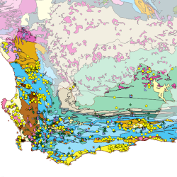
- Title
- Groundwater Database for the Western Cape Province / South Africa
- Description
- This map was produced from various groundwater database projects in the Western Cape.
The base for this map was the import of National Groundwater Archive (NGA) data of the Department of Water and Sanitation (DWS) into a PostgreSQL database, which was then updated with data from the various groundwater projects. - Organization
- Immo Blecher Private Consultant
- Person
- Immo Blecher
- immo (at) blecher.co.za
- Phone
- +27 83 272 6791
- Projection
- EPSG:3857
- Extent
- 1703294.27620332455262542, -4208285.94171678181737661, 2710033.86056353198364377, -3388077.60754683660343289
- Web Map Service
- WMS Url
- WMTS Url