Western Cape
Base Layer

- Title
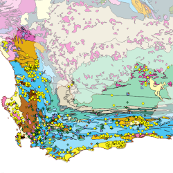
- Groundwater Database for the City of Cape Town and Environs
- Description
- A Water Research Commission Project (Project No. K5/2941):
It has been shown over many years that the efficient management of water resources is almost impossible without a database containing historical and up-to-date information, and data of high integrity. When it comes to groundwater the situation is even worse as groundwater was often not seen as a viable resource, and if it was used, then in many cases, it was poorly managed due to the lack of monitoring and poor data collection.
This has changed in recent years as groundwater now forms a large part of the water sources in several communities, towns and metros. Therefore, the need for properly managed groundwater data has increased tremendously, leading to urgent requirements for a water database in whatever form.
This research project therefore aimed at creating a comprehensive database and visualisation tools which could be used by not only groundwater scientists and managers, but also the public, to obtain easily accessible and up-to-date groundwater information. The public would primarily be able to use it as an education tool and therefore all the layers that can be displayed contain a description on what the layer displays and links to other online resources where more information can be obtained. - Organization
- Water Research Commission
- Person
- Immo Blecher
- immo (at) blecher.co.za
- Phone
- +27 83 272 6791
- Website
- http://wrcwebsite.azurewebsites.net/wp-content/uploads/mdocs/2941_final2.pdf
- Projection
- EPSG:32734
- Extent
- 180767.98562950521591119, 6181060.05060805659741163, 432452.88171955733560026, 6386112.13415054325014353
- Web Map Service
- WMS Url
- WMTS Url